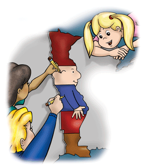
The book is a tool to help kids learn the name and location of the United States. It begins with a helpful character created from 5 states, named MIM (the Man In the Map.)
 MIM uses rhyming verse and lively illustrations to help kids (and adults) learn the states.
 I quizzed the kids before we started reading to get an idea of their grasp on U.S. geography.
States they recognized: (pre-reading)
Ethan = 13 states
Joel = 8 states (which, sadly, did not include the state he lives in)
Honor = 1 state (Also did not include Missouri. She recognized Hawaii because she remembered us pulling out the globe when her grandparents moved there.)
Me = I didn't quiz myself because I was afraid of being embarrassed.
We read the book, but I did not see how they could possibly grasp any of it. They didn't seem able to retain more than half a page at a time. We reviewed as we read and kept plugging along. Later, I quizzed them again to see what they could remember. I was quite wrong about their retention.
States they recognized: (after reading)
Ethan = 36
Joel = 27
Honor = 4 (still did not include Missouri)
Me = 49 (I always forget Connecticut)
The boys did even better when we used the illustrated map.

States recognized (with the illustrated map)
Ethan = 41
Joel = 33
Obviously, things greatly improved after reading the book! But oddly, I'm not overly excited about the book. I think perhaps I'm just not convinced it was the book that gave us such an improvement as much as the concentrated time we spent studying the states. Then again, perhaps not. I wish we had studied the states better beforehand so that I could tell you. Regardless, it was a more enjoyable way than most to spend time studying the states.
I can happily tell you that the book is fun. The illustrations are very appealing. The prose is charming. For example:
"Let's not forget that Michigan has two peninsulas:
The lower one is mitten-shaped,
The upper one has 'paws.'
That dog in upper Michigan's
A frisky, playful pup.
He grabs that mitten in his mouth,
All set to chew it up."
The lower one is mitten-shaped,
The upper one has 'paws.'
That dog in upper Michigan's
A frisky, playful pup.
He grabs that mitten in his mouth,
All set to chew it up."
Cute and catchy! There were a few lines that had me scratching my head, but perhaps I read them with the wrong rhythm. One read:
"Imagination is the magical key
To help unlock the clues you need
To learn geography."
To help unlock the clues you need
To learn geography."
Not bad, but not fluid for me.
It is a large, hardcover book and well worth the price of $19.95. I liked that it included the different regions and emphasized location so well. The shipping is free for the holidays and the author will even sign it for free.
I grew up putting together a puzzle every time I went to my grandma's house. It was a map of the United States. I grew up holding each state, reading them, and identifying their capitals. Geography was never a lesson, it was a game. If you had an auditory learner, reading this book for fun could have the same effect. It was an enjoyable read that even my five year old was happy to sit through. I would like to try the book again, this time matching up each state with a puzzle piece and putting the puzzle together as we read. I think my kinesthetic learner could have all 50 memorized very quickly this way.
I think perhaps Times Tales influenced my expectations for this book too much. I thought that we might be able to walk away with the pictures immediately ingrained in their heads. I fear that I am being unfair to the book with such high expectations. You can see the tremendous improvement my boys gained in their knowledge after a very short time, so you must understand that I am not complaining. It is just that I wonder if they would have had the same benefit if we had spent the same amount of time studying a map or a puzzle. The verse and pictures alone are so plentiful that I doubt most children could remember it all. I don't think the states could be learned from simply reading the book unless they had discussions and review. Happily, Schoolside Press is putting together a teacher’s guide which can be downloaded. I think this would help tremendously! Also, there are coloring pages that can be printed from their website.
My overall impression is that it is not THE product to help your children learn geography in the same way that Times Tales will always be my recommendation for anyone learning multiplication. However, I think it is an awesome resource to enjoy with your child as you sit down together to read and learn geography.
 Don't forget to sign up for the lovely Shanna's Giveaway for this book. The contest ends on the 17th!

2 comments:
GAAAHHHHHHHHHHH! I've seen "the man in the map" since ninth grade. I knew I should have copyrighted it right then and there.
I call him the Continental Chef because Minnesota makes a chef hat.
...is that Minnesota? I spent to much time looking at the chef and giggling at my own unique observation to actually have learned what the states are. His boot is Louisiana, I know that much. ...is that right?
How funny - yes, it's Minnesota. They didn't use the chef hat reference, just a hat. I prefer the chef hat though because I still don't see a hat in that state. And yes, it's Louisiana. You could've been rich.
Post a Comment